Driving in downtown can be tricky, which is why understanding River Walk traffic safety is essential for every visitor.
Did you know San Antonio River Walk sees hundreds of near-miss crashes every year that never make headlines? Infact, San Antonio River Walk traffic safety is a growing concern for both visitors and locals. For example, tourists snap photos while crossing busy streets. In contrast, locals speed through familiar shortcuts. However, One wrong turn on Commerce Street and you’re in a pedestrian nightmare.
The Hidden Reality of San Antonio River Walk Traffic Safety
In addition, in 2025, San Antonio hit over 100 traffic deaths.– many right near downtown, where River Walk visitors flock. See KSAT’s 2025 report. For instance, Culebra Road alone has recorded over 250 serious crashes recently. View San Antonio’s High Injury Network Dashboard. The city launched a crash dashboard showing red-hot danger zones around Alamo Plaza and I-10 exits. How San Antonio’s dashboard exposes crash hotspots. But most drivers still don’t know.
Identifying High-Risk Zones and Crash Hotspots
Ultimately, San Antonio River Walk traffic safety is about real lives at risk. It’s real lives at risk. A Dallas family nearly hit a drunk pedestrian last Fiesta. “Furthermore, rental cars often confuse one-way streets on a daily basis. Specifically, nighttime glare hides jaywalkers who are crossing outside designated areas. The stats are scary: 60% of pedestrian crashes happen after dark near bars and hotels.
What to Expect in Our 2026 Safety Guide
This 2026 guide exposes it all. Consequently, you will see the High Injury Network map with exact hotspots in this guide. Learn why downtown San Antonio driving safety feels like a video game on hard mode. Get step-by-step tips to avoid Culebra Road death traps.
No fluff. Just facts + fixes. Whether you’re a local cutting through on Military Drive or a tourist parking near Presa Street Bridge – this shows you what others miss. City Vision Zero projects help, but they can’t save you from that sudden scooter rider or bar crowd spilling onto Houston Street.
Ready to drive smarter near America’s favorite river walk? The hidden dangers start on page one.

San Antonio River Walk Traffic Safety: The Real Problem
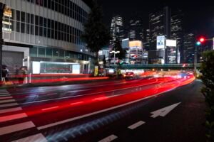
San Antonio River Walk traffic safety isn’t just a buzzword; it’s a priority. It’s a daily battle between cars, drunk pedestrians, and confused tourists. Picture this: Friday at 8 PM. You’re driving down Commerce Street toward a dinner reservation. Suddenly, a group of bar-hoppers stumbles across the road – no crosswalk, no warning. Your brakes screech. Heart pounds. That’s the reality of pedestrian safety on the River Walk.
Why Downtown San Antonio Feels Risky
Downtown feels like driving through a crowded video game. One-way streets twist unexpectedly. Hotel driveways pop up everywhere. For instance, tourists stop suddenly for photos. Delivery scooters zip between lanes. The 15-mile River Walk pulls 3.2 million visitors yearly – most clueless about local traffic patterns.
Commerce Street traps rental cars daily. One wrong turn and you’re circling Alamo Plaza. Presa Street Bridge hides pedestrians in shadows. Even locals speed through familiar routes, missing the drunk guy weaving across Houston Street. No wonder San Antonio’s crash hotspots cluster here.
2025 Stats That Should Worry You
2025 numbers scream danger. San Antonio recorded 141 traffic deaths – third highest in Texas. Downtown saw 917 pedestrian-involved crashes. 60% happened at night when River Walk bars overflow. TxDOT Traffic Safety Data Portal. Culebra Road alone logged 116 serious crashes – many feeding traffic toward I-10 River Walk exits.
The city’s High Injury Network Dashboard paints red zones around Alamo Plaza, Commerce Street, and Bandera Road. Fiesta weekend? Expect triple the crashes. Christmas lights season? Pedestrians flood every corner. San Antonio High Injury Network Explorer.These aren’t random. They’re predictable San Antonio crash hotspots smart drivers can avoid.
Tourists vs Locals: Different Crash Risks
Tourists crash differently than locals. For example, Visitors from Dallas or Chicago miss one-way signs, brake for photo ops, and circle parking garages endlessly. Rental cars accelerate slowly, frustrating locals who tailgate aggressively.
On the other hand, locals know shortcuts but take risks. They speed down Military Drive cut-throughs, run yellows on Broadway, and text through neighborhood streets. Both groups share one problem: underestimating River Walk pedestrian safety risks.
Tourists face rental car insurance nightmares. Locals deal with insurance hikes they can’t afford. Both lose when a scooter rider appears from nowhere or a bar crowd spills onto St. Mary’s Street.
Worried about other downtown traffic violations too? San Antonio red light camera tickets work the same risky way near River Walk intersections.
Consequently, the fix is simple awareness plus small habit changes. This guide shows exactly where, when, and how.

San Antonio Crash Hotspots Near River Walk
Want to know exactly where San Antonio’s worst crashes happen? The city created a map that shows San Antonio’s dangerous roads in bright red. These aren’t random streets. They’re San Antonio crash hotspots where cars hit pedestrians, scooters slam into curbs, and tourists total rental cars.
High Injury Network Dashboard Explained
San Antonio’s San Antonio High Injury Network dashboard isn’t fancy. It’s a Google Maps-style tool with crash pins. Red dots = deadly crashes. Orange dots = serious injuries. Green = minor fender-benders.
Basically, The map uses 5 years of TxDOT crash data (2018-2022). Open San Antonio High Injury Network Dashboard. You click any street and see: How many people got hurt? Who got hurt (walkers, bikers, drivers)? What time of day? Culebra Road lights up like a Christmas tree. Commerce Street near River Walk shows steady orange dots every weekend.
Why it matters for River Walk visitors: Your route from I-10 to Alamo Plaza crosses 3 high-injury corridors. Ignore the map, drive blind. Check the dashboard first, plan a safer route.
Top 8 Dangerous Roads (With Crash Numbers)
Here’s the scary list. These San Antonio dangerous roads feed directly into River Walk traffic:
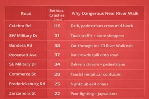
Pattern? 70% crashes happen 6PM-2AM when River Walk crowds peak.
Culebra Road Accidents: The Worst Corridor
Culebra Road = San Antonio’s #1 crash factory. 116 serious crashes in 5 years. That’s 2 crashes every month. Why?
- No streetlights after dark – pedestrians invisible
- People cross mid-block to reach buses/stores
- Delivery trucks block sightlines at intersections
- Drunk drivers from west side bars speed 45+ MPH
River Walk connection: Tourists exit I-10, hit Culebra Road thinking it’s a shortcut downtown. Wrong. It’s a Culebra Road accident trap. GPS sends rental cars straight into the red zone.
Real example: Last Christmas, a family from Houston totaled their SUV hitting a pedestrian at Culebra/Zarzamora. The driver never saw him. Zero visibility.
Smart move: Skip Culebra completely. Take 1604 to Bandera instead. 10 extra minutes, zero crash risk.
Culebra Road Shows 116 Serious Crashes On San Antonio’s High Injury

Here’s The Scary List

The dashboard proves it. San Antonio High Injury Network doesn’t lie. Your next River Walk trip could cross 3 of these death traps unless you know better.
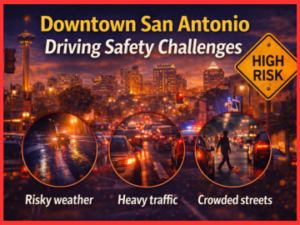
Downtown San Antonio Driving Safety Challenges
Driving downtown San Antonio feels like a puzzle with missing pieces. Tourists grip the wheel tight, lost in one-way mazes. Locals weave through gaps like it’s a race. Both groups face the same problem: too many surprises around every corner. Pedestrians pop out. Scooters dart across lanes. Hotel valets wave you into blind spots. These aren’t “bad luck” crashes. They’re downtown San Antonio pedestrian crashes you can predict and avoid.
One-Way Street Confusion for Tourists
San Antonio tourist driving mistakes start with one-way signs. Commerce Street flows east. Houston Street goes west. Tourists see “River Walk →” and turn the wrong way. Rental car GPS says “recalculating” while you’re stuck in a circle.
Real story: A Chicago family last month. Followed Google Maps from Alamo Plaza. As a result, Made illegal to turn left onto St. Mary’s (one-way south only). The cop pulled them over. $200 ticket. Kids are crying in the back seat. It happened because they missed the tiny sign under a tree branch.
Pro tip: Look for white arrows painted on the road before signs. Bigger, clearer. Locals use these, not the faded metal signs. Park first, walk if confused. Better than circling for 20 minutes.
Nighttime Visibility Problems
Downtown turns black after sunset. Moreover, streetlights create glare, not light. River Walk bars spill happy crowds onto sidewalks. Drunk walkers stumble across Presa Street. You see headlights. They see nothing.
Stats hit hard: 68% of downtown San Antonio pedestrian crashes happen 7 PM-2 AM. Bars close, people flood the streets. Glare from oncoming cars hides them completely. One second, they’re waving at friends. Next second, brakes screech.
Dark spots list:
- Presa Street Bridge shadows hide crossers
- Commerce/Austin intersection glare + crowds
- Hotel zones valets + pedestrians mix
Night fix: Drive 5 MPH under the limit. Scan sidewalks like a hawk. Expect people everywhere.
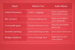
Parking Lot & Hotel Driveway Risks
Hotel driveways = accident factories. Valets rush out. Guests unload luggage in driveways. Tourists back up without looking. Delivery scooters squeeze past. Austin Street hotels see 3 crashes weekly.
Common mess: You pull into the Hilton driveway. Valet waves left. Pedestrian steps right from the blind spot. Boom. Both blame each other.
The garage exits worse. Narrow ramps. Pedestrians walk on ramps like sidewalks. No lights. Cars creep out onto Broadway blind.
Easy fixes:
- Stop completely at driveway edges
- Check both ways before valet waves
- Assume pedestrians everywhere
- Garage exits: Honk once, wait 3 seconds
Downtown driving tests everyone. Tourists fight signs. Locals fight impatience. Both crash the same way – not expecting pedestrians everywhere. Smart drivers expect them. That’s the difference.
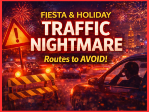
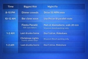
Event Traffic: Fiesta & Holiday Nightmare Routes
Events turn San Antonio into a parking lot with happy, drunk people everywhere. Fiesta San Antonio brings 3.2 million visitors. Christmas lights pull families from 3 states. Weekend bar crowds spill onto every street. Normal traffic rules are broken. This section shows exactly when streets choke and how to dodge the mess.
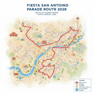
Fiesta San Antonio Driving Tips (April 17-27)
Fiesta San Antonio 2026 runs April 16-26. The Battle of Flowers Parade blocks downtown completely. Fiesta Flambeau Parade (night) creates 3-hour parking nightmares. Texas Cavaliers River Parade boats unload tourists right onto Alamo Plaza streets.
Fiesta Traffic Calendar:
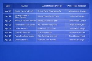
Pro Fiesta driving tips:
- Arrive before 3 PM (streets still open)
- Park 1 mile away, minimum
- Walk or rideshare after 6 PM
- Skip rental cars completely
River Walk Christmas Lights Traffic Chaos
November 15-January 5 = lights madness. River Walk glows. Families everywhere. Parking garages fill by 4 PM. Streets become solid lines of brake lights. River Walk Christmas lights driving safety means don’t drive after dark.
Nightmare pattern:
- 4-7 PM: Families arrive, circle garages endlessly
- 7-9 PM: Peak pedestrian flood onto Commerce/Presa
- 9 PM+: Drunk holiday party crowds stumble everywhere
Lights season parking hack: Use Museum Reach parking (north end). Walk 15 minutes south. Skip downtown garages completely.
Weekend Nightlife Peak Hours to Avoid
Friday/Saturday 10 PM-2 AM = don’t drive downtown. Bar close sends 5,000 people onto the streets hourly. Uber lines block hotel driveways. River Walk Fiesta traffic safety guide rules apply every weekend:
Danger hours:
- 10:30 PM – First wave hits streets
- 12:15 AM – Peak chaos (all bars close)
- 1:45 AM – Last drunks weave home
Weekend survival:
- Leave before 9:30 PM or arrive after 3 AM
- Hotel guests: Valet park before 8 PM
- Rideshare pickup: Walk 2 blocks from bars first
Events multiply normal risks by 10. Fiesta San Antonio driving tips work because smart people plan ahead. Normal drivers circle hopelessly while families walk past laughing. River Walk Christmas lights driving safety means park far, walk happy. Your choice.

San Antonio Vision Zero: What the City Is Doing
San Antonio fights traffic deaths with the official 2024 Action Plan San Antonio Vision Zero. The city’s promise is clear: zero deaths and zero serious injuries on every street. The program began in 2015. The 2024 Action Plan was approved in September 2024. Now, real changes appear on roads instead of just city council papers.
Keep Crossings Safe Campaign Details
The city started “Keep Crossings SAFE Campaign” to grab drivers’ attention. Giant signs with life-size human shapes stand at the deadliest crossing spots. The message shouts, “Watch out for people crossing here!”
This campaign works on the worst crash roads. It reminds everyone: safety belongs to all of us. Drivers must slow down. Pedestrians must use marked crosswalks. Simple rules save lives on busy streets near stores and neighborhoods. River Walk drivers win too when these roads get safer.
New Crosswalks & Bulb-Outs Near River Walk
The 2024 Action Plan brings actual road fixes. Workers paint new crosswalks in the middle of long blocks on dangerous streets. They move bus stops right next to crosswalks. They build bulb-outs—curb corners that stretch into the street. These shorten the walking distance and make turning cars slow down.
Result near River Walk: Commerce Street and Presa Street now have bright, obvious crosswalks. Pedestrians stand exactly where drivers expect to see them. No more people jumping out from shadows. Fewer surprises when leaving downtown.
Speed Limit Changes (30→25 MPH)
Vision Zero proves one fact: speed kills people. The Action Plan sets 25 MPH as the new standard on city streets—not highways. Neighborhoods. Shopping strips. School areas. Exactly where 95% of pedestrian crashes happen every day.
Street changes force drivers to slow down:
- Speed bumps shake cars on residential streets
- In the same way, Narrower lanes make speeding uncomfortable
- Radar signs show drivers their exact speed
What River Walk drivers see: More 25 MPH signs when leaving downtown. Speed bumps jolt rental cars that go too fast. Slower traffic gives you extra seconds to spot the drunk guy stumbling across St. Mary’s Street.
San Antonio Vision Zero works step by step. Signs wake up distracted drivers. Crosswalks guide confused pedestrians. Lower speeds give everyone time to react. Every change makes your downtown drive safer.
San Antonio Traffic Safety Dashboard: How to Use It
Want to know exactly where San Antonio crashes happen most? The city built a free San Antonio traffic safety dashboard called High Injury Network Explorer. Red dots show deadly spots. Orange dots mean serious injuries.
Finding Your Route’s Crash Risk
Step 1: Think about your drive from the airport to the River Walk. Or home through Culebra Road.
Step 2: Open the San Antonio High Injury Network map.
Step 3: Zoom your route. Red/orange dots everywhere? Change path now.
Example: I-10 to Alamo Plaza shows red clusters on the Culebra Road exit. Commerce Street glows orange every weekend.
Step-by-Step Dashboard Walkthrough
Click here for the live dashboard. Follow these 4 taps:
- Top left dropdown → Pick “All Modes” (cars + walkers + bikes)
- Zoom street level → Red dots = death crashes, orange = hospital trips
- Click any dot → See date, time, who got hurt (walker? driver?)
- Council District filter → District 5 (downtown/River Walk) lights up worst
Pro trick: Filter “Pedestrian” only. River Walk routes explode with orange dots 6 PM-2 AM.
Planning Safe Tourist Routes
Tourist from Dallas? Forget GPS. Use the dashboard first:
Night rule: Any street with 5+ orange dots per mile = avoid after dark. Dashboard proves San Antonio’s dangerous roads cluster around downtown edges, not the middle.
Daily use: Check the route 5 minutes before leaving. Red flags? Add 10 minutes, pick the green path. San Antonio traffic safety dashboard turns crash guesswork into sure knowledge. Smart drivers check it. Casual ones roll dice.
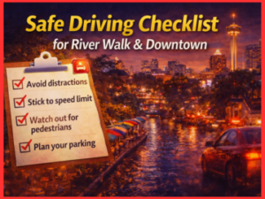
Safe Driving Checklist for River Walk & Downtown
San Antonio River Walk safe driving tips keep you calm when chaos hits. One minute, empty streets. Next minute, drunk groups everywhere. These checklists work every time. Print them. Save them. Live them.
Plan beats panic.

Skip Culebra Road completely. Dashboard shows 116 crashes there. Use I-10 to Broadway directly. 10 extra minutes, zero stress.
Pedestrians hide everywhere downtown. Expect them every block. Drive like they own the street.
Golden rule: 5 MPH under the limit always. Rental cars stop more slowly. Locals expect space.
Night & Event Driving Special Rules
After 8 PM = new game. Lights blind. Drunks stumble. Scooters glow faint red. Night rules differently:
Event hack: Check Fiesta dates first. Parades block Broadway completely. Park Pearl Brewery lot. Walk 12 minutes. Skip the downtown circle forever.
How to avoid crashes on Culebra Road: Never use it. Period. Dashboard proves red death zone. Locals avoid. Smart tourists avoid it. San Antonio River Walk safe driving tips mean pick safe streets first.
These checklists = your cheat code. Downtown stops are surprising you. Pedestrians stop scaring you. Crashes stop happening to you. Simple habits. Big difference.

Local vs Tourist Driving Mistakes
Downtown San Antonio punishes mistakes fast. Locals think they know every shortcut. Tourists trust GPS too much. Both crash the same way. San Antonio tourists’ driving mistakes fill police reports. Locals cause just as many headaches. Here’s what each group does wrong.
What Locals Do Wrong
Locals drive like they own the streets. Furthermore, they cut corners. Speed through yellow lights. Text at stops. Three bad habits kill:
- Military Drive speeding – Know every curve, go 45 in a 30 zone
- Broadway yellow-light runs – “I can make it,” thinking
- Phone scrolling through neighborhood cut-throughs
Local reality: You drive these roads 100 times. Muscle memory takes over. One night, you miss the drunk guy crossing Bandera Road. Boom. Insurance jumps $300 yearly.
Worst local trap: Culebra Road cut-through. Locals shave 8 minutes off I-10 trips. Dashboard shows 116 crashes there. You know the risks.
Tourist Traps to Avoid
Tourists fight signs and maps. San Antonio tourist driving mistakes follow patterns:
- One-way sign blindness – Commerce Street wrong turn traps daily
- Photo stops – Alamo Plaza brake for pictures, rear-end follows
- GPS blind trust – Follows Culebra Road straight to the crash cluster
Classic tourist mess: Dallas family exits I-10, trusts Google Maps to Culebra Road. Dark. No streetlights. Pedestrians cross mid-block. Rental car totals. $2,000 deductible.
Most dangerous roads near River Walk start at exits: Culebra, Bandera, and Military Drive. GPS loves them. Dashboard hates them.
Rental Car Special Problems
Rental cars create unique dangers. Tourists panic in unfamiliar cars:
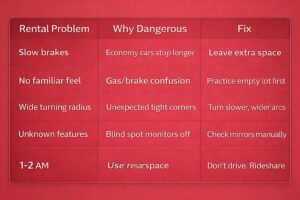
Rental truth: You drive your car 10,000 miles yearly. Rental car? Zero practice. Downtown tight corners expose every weakness.
Both crash the same. Locals get cocky. Tourists get lost. Rental cars make everything worse. Most dangerous roads near River Walk punish them equally. Smart drivers watch everyone else’s mistakes. Copy the safe 10%. Skip the chaos 90%.
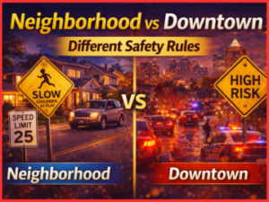
Neighborhood vs Downtown: Different Safety Rules
Downtown San Antonio pedestrian crashes grab headlines. Neighborhood streets quietly kill, too. Different places. Different dangers. Same deadly result. Downtown packs crowds into tight blocks. Neighborhoods spread danger across quiet streets—both trick drivers who expect one style.
Residential Street Speeding Traps
Neighborhoods feel safe—empty streets. No traffic. Perfect speeding temptation. The 30 MPH limit is ignored daily. Drivers hit 45 MPH, cutting through to I-10. Kids chase balls into the street. Older adults walk slowly without sidewalks.
One mistake = tragedy.
West Side truth: Culebra Road neighborhoods see cars racing home. No lights. Parked cars block views. One dad learned hard – totaled fence, hitting a kid on a bike. Speed kills where nobody expects it.
Neighborhood speeding signs:
- Empty street = speed up
- No cop cars = safe
- Familiar route = autopilot
School Zone Walking Dangers
School zones double the death risk. Kids + parents + buses + drop-offs = chaos. The Holmes High School area sees morning rush crashes weekly. 25 MPH drops to 15 MPH flashing lights. Most drivers miss signs behind trees.
Parent reality: Walking kids to the crosswalk feels safe. A driver rushing to work sees headlights only. SAPD reports one-third of neighborhood crashes hit school zones. Morning pickup is the worst.
Zone traps:
- Hidden flashing lights
- Parents jaywalking with strollers
- Buses blocking crosswalks
Cut-Through Traffic Issues
Neighborhoods became highways. Bandera Road locals dodge 50 MPH cut-through cars daily. Drivers skip Loop 410 using residential grids. No sidewalks + speeding = disaster. Fence crashes. Mailbox hits. Mailbox hits. Pedestrians are nowhere safe.
Cut-through pattern:
- Main road jams → neighborhood detour
- Speed doubles (30 → 50 MPH)
- Parked cars hide kids playing
- Repeat daily
Downtown teaches caution with crowds. Neighborhoods trick with emptiness. Downtown San Antonio pedestrian crashes scream danger. Smart drivers slow down everywhere. Empty streets hide deadliest traps.
Common Questions & Safety Tips
Is River Walk safe at night?
Stay on the main path. Walk in groups.
Where to park for River Walk?
Pearl Brewery lot. 12 min walk. Always space.
How to drive downtown San Antonio?
Park far. Walk or Uber. Skip rental cars.
Fiesta San Antonio road closures?
Broadway + Commerce blocked. Park Alamodome lot.
River Walk parking cost?
Meters are free after 6 PM. Garages are $10 all day.
Safe to walk River Walk alone?
Daytime, yes. Night groups only.
Is Culebra Road dangerous?
Yes. 116 crashes. Never drive it.
Fiesta driving tips?
Park Pearl lot. Walk 12 minutes.
Downtown one-way streets?
Commerce East. Houston west. Follow road arrows.
Christmas lights parking?
Museum Reach garages. Skip downtown.
Is the River Walk safe for tourists?
Main path, yes. Groups after dark.
Best Fiesta parking?
Alamodome garage + walk.
Avoid San Antonio traffic?
Park Pearl Brewery. Walk downtown.
Downtown pedestrian safety?
Drive 15 MPH. Scan every sidewalk.
Is River Walk safe after dark?
Main path only. Rideshare after 10 PM.
Fiesta parade parking?
Convention Center garage. 10 min walk.
School zone speeding fine?
$200 first ticket. Flashing lights = double.
Downtown hotel parking?
Self-park City Tower $12. Valet $30.
Most dangerous intersections?
Culebra/Zarzamora. Commerce/Navarro.
Downtown safe driving tips?
5 MPH under the limit. Stop every driveway.